I already sent it to the Help address, but will send other stuff direct if and when I come across it For example I will send a GPX file that caused the hang.

I like the new function and managed in the meantime as well to get the animated locations on the route. It would help if the bars would have the “segmentation” as it is with FM5.
Sadly, I tried the converter you recommend and I still had FM6b crash when I added a Place Marker created in Google Maps. If it’s a bug, hopefully the devs will be able to resolve it.
I tried only converting to tracks, but you are right by using a converted waypoint file you have to kill spinning beachball of FM6.0b14
A file that only contained waypoints, but no tracks caused the problem. This bug has been fixed in b15. At the moment only waypoints, but no track is not supported, but this feature request has already been noted.
Peter, I am not sure what you mean by “no track is not supported”! I was able to import a GPX of a track I created in Google Maps. Interestingly, it was a river route that I had to create manually, and I noticed I was able to tweak it in FM6b by grabbing and moving points along the route. Not sure if that means you can create a manual route within FM6 itself: it would be a nice feature, although driving routes might be more difficult unless you can access Google Maps (or similar) yourselves and integrate it.
I still have the GPX files I tried before, so will give them another go in b15.
Any news yet on the missing opacity feature in Text?
I was talking about GPX files that contain only (disconnected) waypoints, but not a (connected) track or route.
However, Adrian already made the feature request for standalone waypoints, which are not connected via a line. That is something that I will add in a future version.
Thanks for the clarification. Future version or future beta?
I will look at importing a GPX from Google Maps with both start and finish points AND the actual route (as before). I’ll be interested to see if it can be animated.
To be honest, I’m not sure yet how soon this feature will be coming…
I do hope so. I have been teaching myself how to use Google Earth Stdio, but unlike FM6 you can’t animate the route tracks!
Latest beta (15) still does not show waypoints on files imported from Google Maps
A couple of questions that someone may be able to answer, even though they aren’t strictly related to the beta:
- I am experimenting with placing waypoints on a map within FM6b (since I can’t import them from Google Maps, see above). However, when zooming, the waypoint moves, since it’s not locked to the image layer. I thought the “locked” function would achieve this, but it seems to do something else. Is there a way to lock the two layers together without guesswork, ie. by placing the text box manually in the Finish frame?
- On the fonts pulldown, all sorts of fonts are listed that are not on my system. Is there a reason for this?


First in regard to the “Locked” feature – what that does is “lock” a layer so it can’t be moved or selected accidentally while moving other elements. It does not “lock” one layer to another. You might get into a habit of UN-locking it afterwards, just in case later on you try to modify that layer and find yourself stuck. You also can’t delete a layer that is locked, and that might confuse you later as well.
Now as for the “movement” of the waypoint on the map. I’m assuming here you are NOT talking about a waypoint that you placed from within the Map Assistant (because that will stay at the same place on the map whether you pan it, zoom it, or rotate it), but a dot, spot, circle or some other point that you placed manually on the map? Along with the text manually placed on the map? THAT is very hard to control if you’re trying to animate one layer and other layers above it (like the map AND the waypoint AND the text). There is no way to “group” them together so they behave as a single image.
There IS a way to tie the waypoint together with a label if you want to, but you have to do that as text. Use a bullet, for example (usually Opt-8 on the keyboard, and depending on the font), and the text label, and create it as a single text block. You can adjust the size of the dot, it’s color, and the label, along with any centering, adjusting leading, spacing, etc.) so that it becomes a single ITEM. Then you can place that on the map layer – BUT – you’ll still have difficulty of having it move along with the map layer below it in sync. There IS even another way, but it’s more complicated (create the map as a specific size and shape in Photoshop or similar, then create the waypoint and label in another document in .png format that has the exact same document size as the map layer, then place them on the FM stage, one layer above the other, and whatever movement you assign to the map, assign the same animation zoom, rotation, and pan for the waypoint/label layer.
As for your fonts – are you SURE they aren’t on your computer SOMEWHERE? They don’t have to be in YOUR user Library Fonts folder – they can be in the System Library Fonts folder as well. Without a Font Manager to control which fonts are turned on or off by you, then ALL of the fonts on your computer will display at once. I just did a quick search in my System Fonts folder and a whole bunch of fonts you have showing are in my folder as well. If you own a Mac, you’ve probably got 'em all!!
Thanks, as always, for the detailed explanation.
I think what the Maps Assistant needs is the ability to create waypoints that are not connected and that can be named, as can be done with Google My Maps. Then a route can be imported from eszlewhere as a GPX file.
Since I have not imported from a GPS I don’t know how that works: are the waypoints named when the file shows up in FM6b?
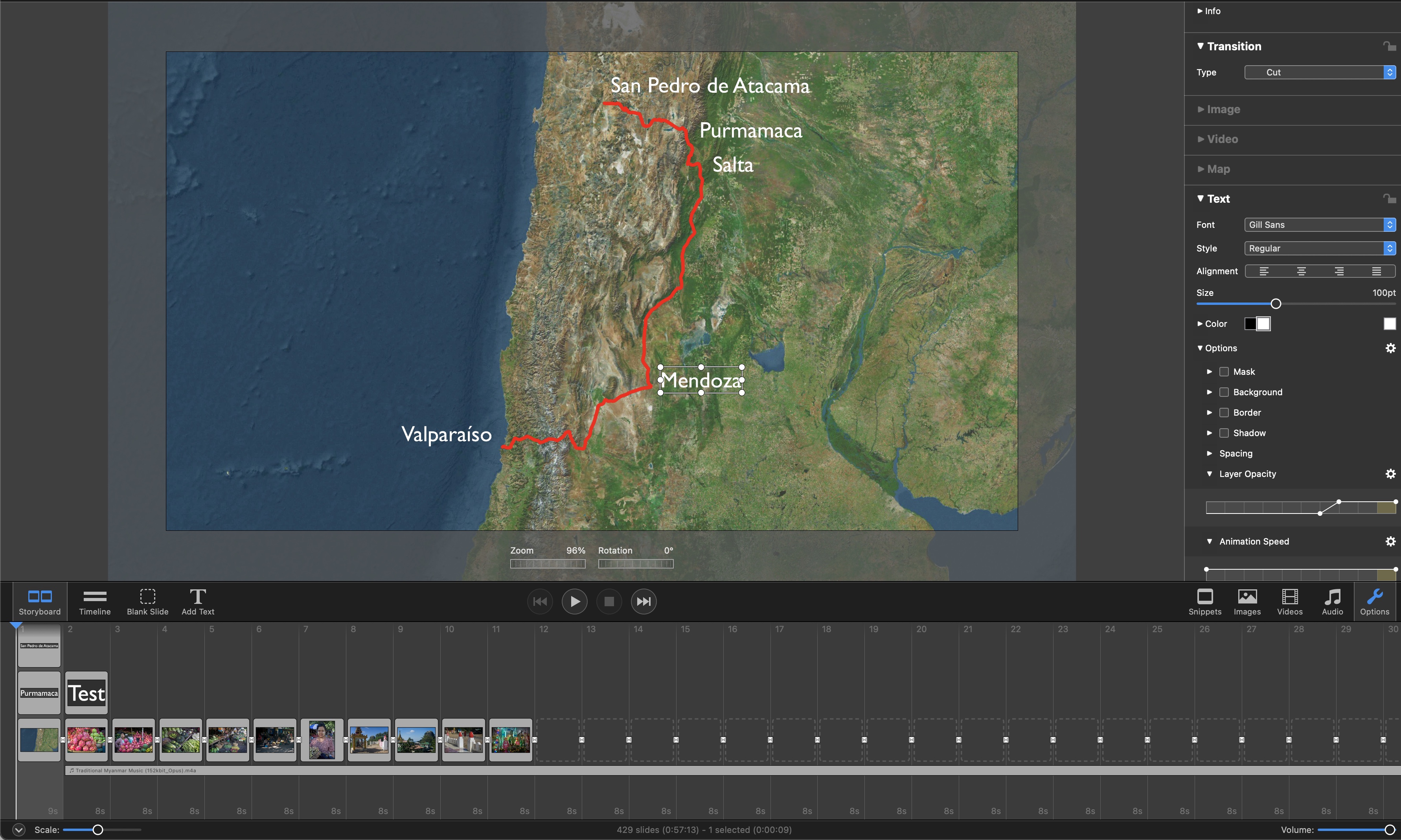
In the example below, I created two waypoints but had to map a route between them manually. There is no way of knowing what the names of the start and end points are, except in hybrid view.
Re fonts: the bizarre issue I have is with symbol fonts like Webdings. Font Book says they are installed on my MacBook Pro, but they don’t show up in TexEdit or Pages, let alone in FM. I checked with a friend who has an older OS and he says it’s the same for him. They only way to import a symbol is to click on it within Font Book. Maybe that’s the way it’s meant to work.

Standalone waypoints (without a route) will be coming in the future, but I do not have a timeframe yet…
As Peter mentioned, standalone waypoints are currently not supported. I’ve done a lot of trips where I record my track on my Garmin handheld GPS unit, and they are saved as a .gpx file. Individual waypoints can be saved and named, too, but they are handled differently – they are not a part of the track file. So when you import the track, that’s all you get – just as though you were clicking points in the Map Assistant and connecting the inflection points, but of course they are more accurate and true to where you actually had been.
Two further suggestions:
- It would be nice to have the ability to zoom in and then stop the zoom before the end of the map slide. This would create a more dramatic effect, and then the actual track file can be added while the map is not zooming and waypoints can be added manually.
- I find the layer opacity box in the Text module VERY difficult to manipulate, using a trackpad. Clicking on the dots is very hit and miss for me. In FM5 it’ still not exactly easy, but easiER!
Regarding 1) Use animation speed in Map>Options to ease out the zoom way before the end of the slide to achieve what you want.
Regarding 2) Yep you are right - clicking and dragging the curve control points can be tricky if you are only using trackpad.
Thanks Peter. Re (1) I now know how to achieve what I want. Re (2), I think the boxes are smaller than in v5, making it more difficult to move the points. I wonder of there’s a way the sidebar could have the option of being made larger so that everything is easier to manipulate. Or an option to type in the values rather than sliding the points around.
Peter:
Brilliant. I have now got what I want. I have also exported the slide as a Pro Res movie, so I can use it in a slideshow I am making in v5. I am not making any in v6 yet, since a major feature I use for my Text overlays (opacity option for backgrounds) is not yet available.
The slide is 10 seconds, but the mov file is 18, with 8 seconds of blank screen before the animation begins. Any reason for that?
I also notice there is no longer the option to share as Standalone Player. Again, any reason?
I am happy to share this maps animation, but of course the file is too big to post here. Any suggestions welcome.