We would love to see your work! If you can, please share.
Not ready to share anything, but the Maps Assistant is pretty cool. Would like to be able to, for example, create a quick route from Los Angeles to New York, but having figured out a “fast” way to zoom out and see a bigger part of the world all at once. Still playing with it.
Doh – just found the tiny zoom “-” and “+” at the bottom right. My mistake – ooops!
Hi @stantastic Thanks for giving it a try. It is important that we collect as many potential use cases as possible to see if the Map Assistant works for people.
Most of my slideshows start with a map, which I currently prepare in Google Earth and then save to screen. So this could be something that interests me. But I’d need access to the beta first!
I sent you the download link via direct message.
Thanks for giving it a try!
Thanks I have received it.
I need a tutorial to help me create a map that would suit me. At a cursory glance I cannot see how to even begin to create a map of the area featured in a particular slideshow.
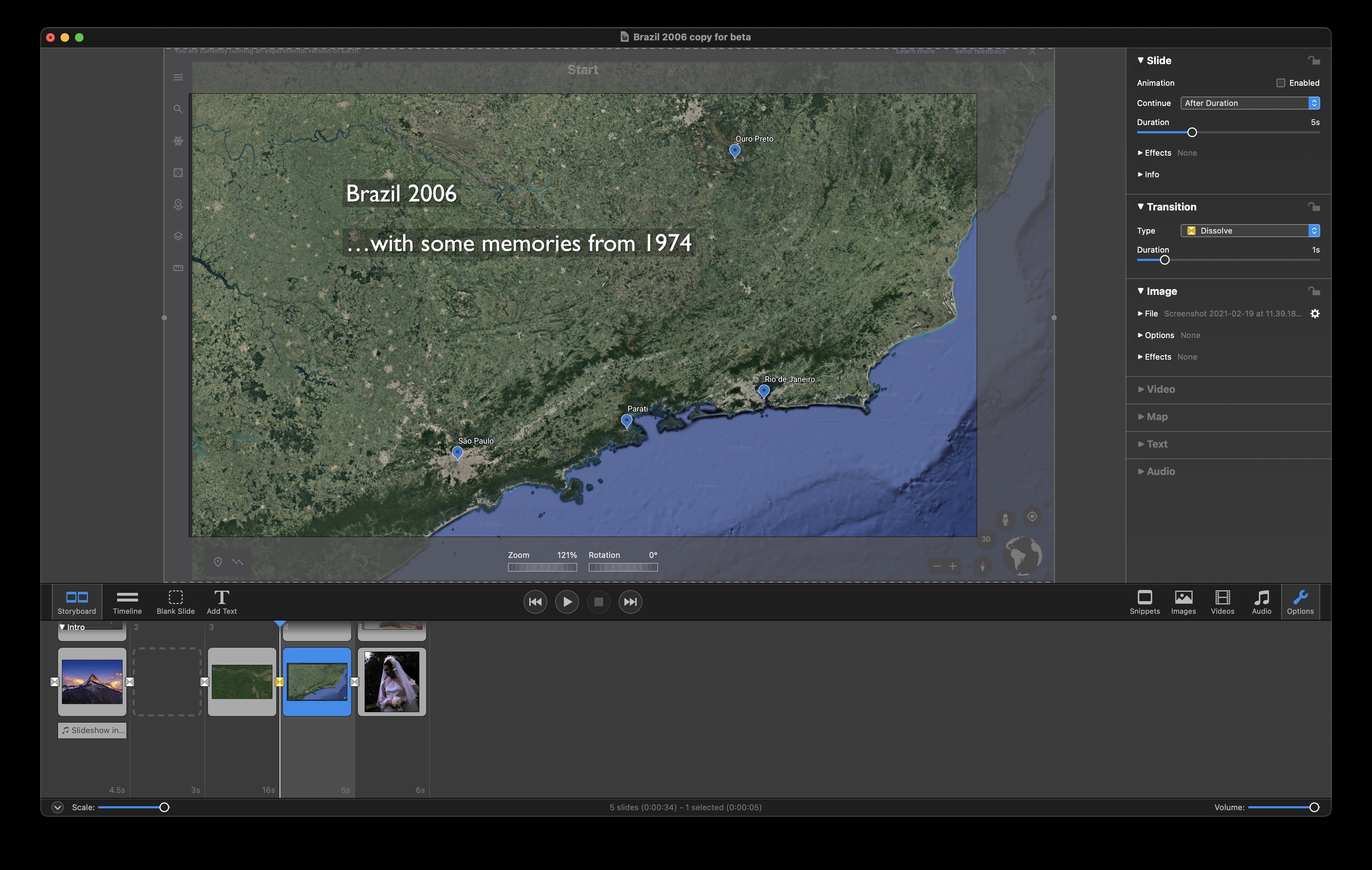
This is a screenshot of the sort of thing I create with Google Earth. Apart from using the text feature in Fotomagico to do fade ins and out, I have been stuck with a static destination placing and no route.
You can also use two-finger pinch & zoom gestures on the trackpad to zoom the map.
I have no idea how to find the map I need. When I open Maps Assistant, all I see is a map of a river somewhere.
This definitely requires a tutorial. And I assume there will be a new version of the online guide.
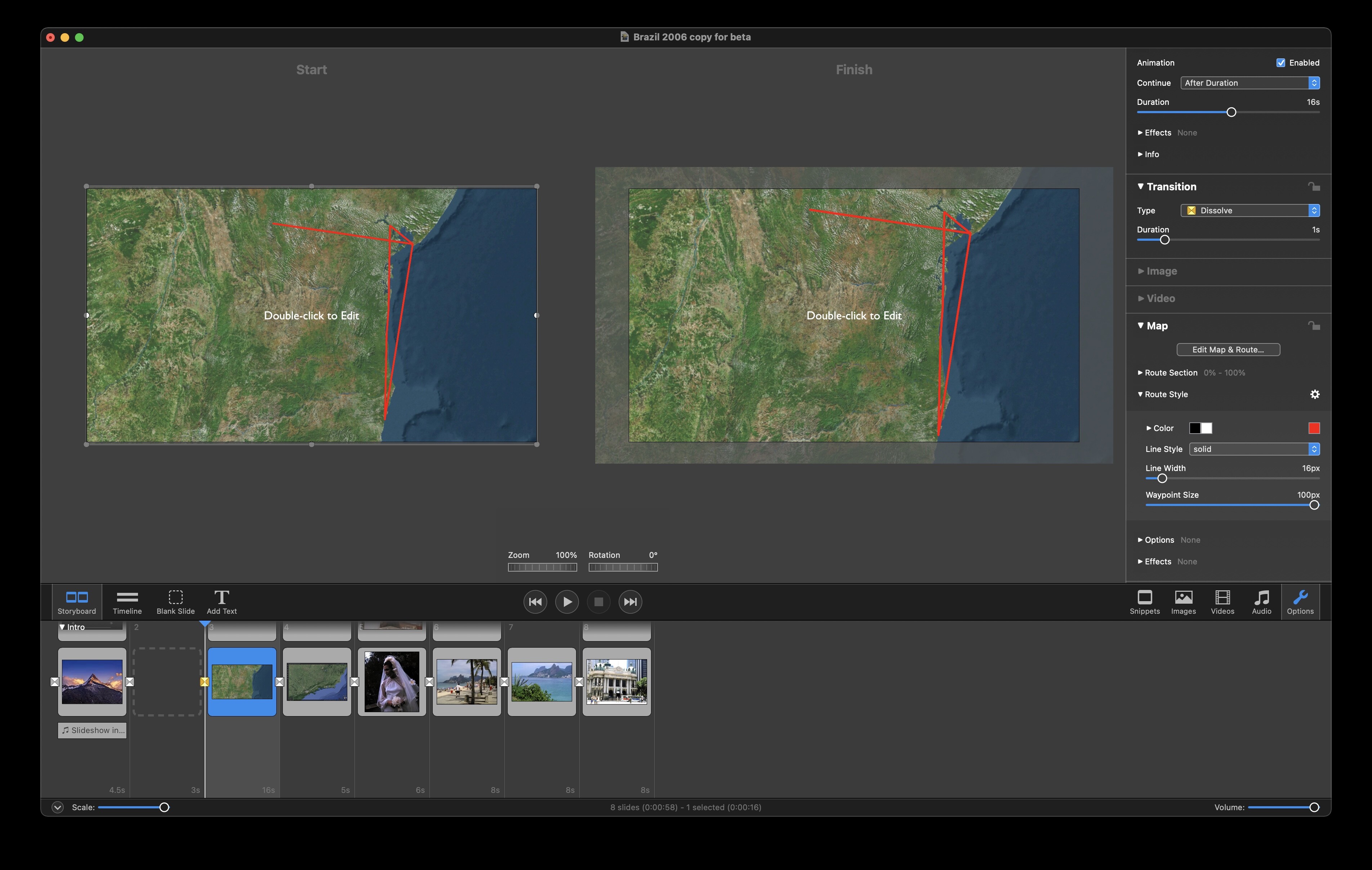
I had a bit of a problem when I first started as well using the Map Assistant. When you start it, it automatically zooms to an area in Germany near Munich (that’s what you’re seeing). At the bottom right corner you’ll find some very small “-” and “+” icons. Click those to zoom in and out. Clicking on the map and dragging will move you to where you want to go. Click on the “Edit Route” tab at the top to start creating a route. You can click from one point to another to create straight lines, or click in the middle of a segment to add a point and move it, do a Command-Click on a waypoint to delete it, or do an Option-Click on a segment to create a bezier curve (which I wish could be used to create paths for animating layers in a slide show). Once you’re done with your route, click on the OK button at the bottom right and the slide will be created and placed in your timeline.
You can then apply different characteristics to the route in the Options > Map Panel. So far, I’m still finding things NOT working (like in the Route Section drop down options “Showing route before start with opacity” and “Waypoint Size” in the Route Style drop down options). Line width, color, solid, dotted, and dashed all seem to work, along with the animation speed and adjusting the start and end points (although the small scroll dials under start and end really are useless since you have to scroll from one end of the other on the dial to just change by 1%).
But it’s a start – I’m liking SOME of the new features that have been added to the overall app, but there are some that are now missing or don’t work correctly. Hey, it’s a beta version!!
Thanks for the feedback. Please report anything you’re missing and that doesn’t work korrectly. Yes, it is a beta version, but it should be feature complete.
Thanks, Oliver – I have sent a couple of “Beta Feedback” replies previously. The newest b07 version has some of the same issues regarding the Maps panel options as b06, although the b07 update mentioned a number of things fixed in the Map creation process (which I either didn’t experience or it just didn’t draw my attention). There was something mentioned about fixing the in-space duration marker (was that what it was called)? I still can’t click or double-click on a “duration” interval on the timeline itself to make a direct change to the timing. The slideshow timer still just scrolls to that slide. And the horizontal slider seems to superimpose OVER those duration markers anyway.
I had typed in Brazil in the maps assistant and it had indeed found a river somewhere in Brazil. It was not the area near Munich he mentioned. I guess that’s where Boinx is located. So the obvious would be for it to default to one’s own location.
Once I’d zoomed out, as suggested by Stan, I was able to see the entire country.
I will take a look again soon.
I have had a look at it and experimented a bit. I prefer the satellite view for my maps, so it would be nice if one could add the names of towns to it, as they only show in dual view, and that for me is a bit too cluttered.
I also thought I saw somewhere a slide showing the land route between two points. Maybe I am wrong and maybe it would be too complex to be able to use it.
Not sure what the GPX button is for. All I know (from googling) is that gpx is a file extension indicating a GPS data file.
Hi, Londinense –
Seems like there is a text editing problem, and not just confined to the satellite view (has nothing to do with which type of map you decided to use). You should be able to add names of towns, etc. Try clicking on ANOTHER slide, then coming back to the map slide and try it again. Programmer is currently working on the issue.
The “land route” you are talking about can be created by clicking on the Route" button on the Map Assistant, then just clicking on the various points to create a route. After Apply it inserts the map into the slide show and then you can modify the route using the new Map panel.
Since I geocache (a LOT!) I am very familiar with a .gpx file. That’s pretty much a standard format for waypoints and routes created from GPS units. If you were to have a handheld GPS unit (like a Garmin device) you can create a track of where you hiked, drove, sailed, whatever, and save it as a .gpx file. Then you can download it from the GPS to your computer, and use that file as an input to the Map Assistant using the GPX button. It then displays that route on top of the map in all its glory.
Wow, that’s cool, like it very much. Just uploaded a gpx file and got our summit tour to Mount Semeru displayed and animated. Works great. Only had problems with the “blaue Anfasserpunkte” which didn’t worked. Generally its a fantastic feature IMHO, thx.
2nd check with displaying a route from Frankfurt to Ashgabat. First just looking for “Frankfurt” brought me to Frankfurt Oder. Second it is not very user-friendly to go to “Karte bearbeiten” and to look for a city, then to switch to “Route bearbeiten” so set a waypoint, then to go back to “Karte bearbeiten” to find a second place and again to go back to “Route bearbeiten” so set second point.
Also I’d like to have an easy option to go back from a “curved line” to a “straight line”. At the moment I have to delete every single track point, right? Like that feature very much but it needs a bit more usability I think.
Sorry, its me again  Put two maps in a row with two separate gpx files. Had an animation (zoom out) in the first one with “Fortfahren Interaktiv”. Slide stops correctly but animation doesn’t, its zooming out and out and out
Didn’t quite follow you on that – but then figured out what you were describing. Confirmed, it does what you say. I’ll send a Bug Report, even if you did already.
If you find bugs, suggest you send them via the “Beta Feedback” menu option under the main “Help” menu (although posting them on the forums here let’s other beta testers know as well).
1 Like
Many thanks and yes, I do both. And your are right: forum is good for other testers to know, Beta Feedback good to get it directly sent to the developer.